Coastal community case studies
Rosyth
Population 2019: 15,902 Projected Population 2030: 15,049 Land Area (hectares): 2,814.07
Rosyth is located on the Firth of Forth, south of Dunfermline. The Royal Naval Dockyard Rosyth was constructed in 1909 and the town was planned as a garden city to accommodate the construction and dockyard workers. Around 2000 houses were built up until 1925 when the dockyard closed and there was little growth until 1939 when the dockyard reopened due to the outbreak of the Second World War.
Babcock International acquired the dockyards in 1987, making Rosyth’s dockyards the first Royal Navy dockyards to be privatised. The privatisation followed almost eighty years of contribution to the defence of the United Kingdom. During this time, Rosyth was a key nuclear submarine maintenance establishment. The final nuclear submarine refit occurred in 2003 and since then there has been a nuclear decommissioning project of the submarine and refit facilities, which was completed in 2010. The associated naval base closed in 1994 and there are now no Royal Navy ships permanently based at Rosyth.
Much of the employment in Rosyth focused on the dockyard and since its decline there has been other industries coming into the area, such as Sky (media), Lexmark (printers) and Intelligent Finance (financial services).
According to the Brexit Vulnerability Index (BVI) three of the 21 data zones have a BVI score of 5 or under with 10 being the lowest vulnerability – click on the link for more information on the BVI and its formation), indicating that it is an area that is not expected to be greatly impacted by Brexit.
Inverkeithing and Dalgety Bay
Population 2019: 17,493 Projected Population 2030: 15,385 Land Area (hectares): 1,720.17
The ward of Inverkeithing and Dalgety Bay sits just along the coast from Rosyth and continues up to Burntisland. It is a ward that contains two quite different areas. A historic town: Inverkeithing, and a new town: Dalgety Bay.
Inverkeithing is a town that received Royal Burgh status during the reign of Malcolm IV in the 12th Century. Although there is some suggestion that the area was an established settlement even earlier than this, in the 5th century AD. It was a flourishing market town up until the 17th century when the town became ensconced by an unusually large number of witch trials and was the place of a battle between the English and Scottish.
More recently, Inverkeithing’s main industries were quarrying, engineering and shipbuilding. These all died down by the 1920s and a paper mill was established. This lasted until 2012. Inverkeithing has increasingly become a commuter town for Edinburgh with a popular park and ride at North Queensferry.
Dalgety Bay was built in the 1960s and was Scotland’s first ‘enterprise town’. It is primarily a commuter town for Edinburgh.
Aberdour is just further north along the coast from Dalgety Bay. It is a small, scenic, and historic village and is a popular place to visit. It was voted second best place to live in Scotland in 2018 by the Sunday Times.
Five of the 25 data zones have a BVI score of 4 or under.
Buckhaven, Methil and Wemys Villages
Population 2019: 18,079 Projected Population 2030: 16,981 Land Area (hectares): 2,732.69
This ward is situated along the coast, between Kirkcaldy and Leven. Buckhaven was a thriving fishing and weaving village until the 1860s, where it became focused on mining. The coal waste from the mining polluted the shoreline of the area and regeneration is in progress to alleviate its impact. The area suffered decline when the mines closed. The railway station is reopening in 2023 after being closed for over 50 years. This is expected to contribute towards the regeneration of the area.
Methil was similarly reliant on coal extraction. It had a significant coal port. The closure of the mines also led to decline in this area. Methil Power station was developed in 1960s to use the colliery slurry that would have gone to waste. It was demolished in 2011. Now Methil is turning to green energy, with a hydrogen energy project based in Methil Docks Business Park.
14 of the 25 data zones have a BVI score of 3 or under, making it an area highly vulnerable to Brexit.
East Neuk and Landward
Population 2019: 12,272 Projected Population 2030: 12,772 Land Area (hectares): 19,321.27
The East Neuk and Landward consists of the coast and a small amount of inland area from Elie/Earlsferry up to Boarhills. Neuk is an old Scots word for corner, or nook, and the East Neuk it is the east corner of Fife. It has been significant in Scottish history due to the role it played in fishing, trading, and religion.
Nowadays, the East Neuk is still famous for fishing, especially shellfish, however its main industry is tourism. The area is renowned for being a popular place for holiday homes for people from other areas of Scotland and the UK, as well as being a popular daytrip for international visitors to Edinburgh and Scotland generally. This makes it an interesting area to explore the impact of Brexit, as those involved with fishing in the area were reportedly pro Brexit due to their previous experience of alleged overfishing by European fishing boats coming to the areas surrounding the East Neuk to fish. However, some of the tourism industry depends on European migrant workers, many of whom would be unlikely to meet the salary threshold for a tier 2 visa post Brexit. Without immigration the area currently does not have natural growth and depends on immigration to partially offset an ageing population.
The uncertainty of the impact of Brexit on migration and the possible knock-on effect this may have on the area’s workforce means there is potential for demographic and economic challenges in the future.
Due to the fact that this ward is significantly larger to the others there is some further information on key areas in the East Neuk:
Elie and Earlsferry
The Burghs of Elie & Earlsferry were united in 1929, but they were once separate burghs with very different origins.
Earlsferry is the older dating from the 11th Century. The Earls of Fife held land at Earlsferry and at North Berwick across the Firth of Forth. A ferry supported by the Earls plied between the two places mainly for pilgrims heading for St Andrews, hence the village name. In 1541 Earlsferry became a Royal Burgh allowing it to trade overseas. In 1600 however the ferry had ceased and the town never developed with most boats using the better harbour of Elie.
Elie grew up around the bay which provides a safe anchorage protected by an island with a causeway. It became a Burgh of Barony in 1589 under the Lairds of Ardross. As such Elie was forbidden to engage directly in foreign trade and was dependent on the Laird of Ardross who controlled the Town Council and Court. In the 1850s the harbour was improved and a road built on top of the causeway. Fishing and trading were carried from the harbour and goods were stored in the granary at the end of the pier. The granary, which lay derelict for many years, was recently restored and converted into flats.
Today its long beach proves a popular tourist destination. According to the BVI it is highly vulnerable scoring 1 and 2 out of 10. This makes it within 20% of the most vulnerable to Brexit areas in Scotland.
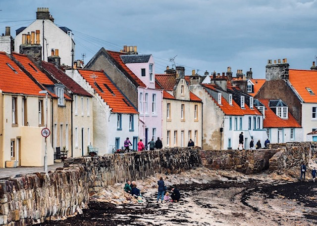
St Monans
St Monans is named after the Martyr Saint Monan who was martyred on the Isle of May, thought to have lived in the 6th-7th century. St Monans was famous for making salt in the 18th Century. At this time salt was Scotland’s third largest export after wool and fish. It was called white gold and was traded across Europe. However, with the repeal of salt duty in 1823 and the import of cheap rock salt from abroad the salt industry collapsed. The remnants of nine salt pan houses are still visible by the coast. The salt windmill was restored in the 1990s. The salt industry in St Monans is being revived with a new business, East Neuk Salt Co, established in 2019, working on producing salt from the sea around St Monans again.
According to the BVI, St Monans is vulnerable to Brexit with a score of 3 out of 10.
Pittenweem
The fishing village of Pittenweem was declared a Royal Burgh in 1541. It has a history of religion, fishing, trade and witchcraft. The priory that was once on the Isle of May moved to Pittenweem in 1318 to ease the threat of pilots and became under the administration of the Augustian monks of St Andrews. The priory brought a boost to the area and there was a lot of trade from there across the channel. The priory also had many underground passageways that connected to Fillan’s cave (a current tourist attraction) which was also popular with smugglers at the time. There were also several witch trials held here and the local witches were drowned in Kilconquhar loch.
Currently, Pittenweem is the key area for fishing in East Neuk, with a lot of prawns, crabs, scallops, lobsters, clams and razor fish fished here. It is suggested (by the courier) that many of the fishermen from this area were pro-brexit due to the overfishing of the 1990s. There is also the Pittenweem art festival that happens for a week each August. Local artists and invited artists exhibit in the many galleries in the village. It attract many tourists.
According to the BVI it is not a highly vulnerable area to Brexit, with the two data zones scoring 6 and 7 out of 10
Anstruther
Anstruther is the largest village and is described as the heart of East Neuk. It was one of the busiest port of the area. It has a long history of fishing which is told in the famous fishing museum. The museum tells the story of fishing on the whole of the East Coast of Scotland and is housed in a building that has been associated with fishing for over 400 years. It acts as a memorial to the many men who have lost their lives at sea for their occupation. There is also a famous ‘Shell House’ – a house decorated in shells in the 1840s by Alex Bathchelor (who also decorated his coffin in shells and charged people to see it). The house was a notable attraction and was visited by Robert Louis Stevenson who described it in his journals as of the ‘agreeable eccentric’.
Today Anstruther is focused on tourism. It is mostly pleasure cruises that leave its harbour rather than fishing boats. It is from here that people leave to see the Isle of May, an island famous for its puffins and old priory. It has a fish and chip shop that boasts to be the best in the UK.
It is an area of mixed vulnerability with one datazone being at the lowest level of risk, scoring 10, next to a datazone scoring very high risk level of 2.
Crail
Crail became a Royal Burgh in the 12th Century. Robert the Bruce granted permission to hold markets on a Sunday, in the Marketgait, where the Mercat Cross now stands in Crail. The decision caused such outrage in religious circles that John Knox delivered a sermon at Crail Parish Church in the Marketgait damning the fishermen of the East Neuk for working on a Sunday. Despite the protests, the markets were a huge success and were amongst the largest in Europe. There was a lot of European influence on the town with some architecture very similar to Dutch styles, and the Bell in the town hall coming from the Netherlands. Some suggest that the oldest golf course was actually in Crail. Close to Crail, there was a cold war bunker built for government use in 1951. It was operational until 1993 and is now a major tourist attraction. Tourism is important for Crail. It has an annual food festival and is known for its pottery.
According to the BVI it is highly vulnerable to Brexit, with a score of 2 and the surrounding area having a score of 1. This means Crail and its surrounding area are within 20% of the most vulnerable areas to Brexit in Scotland.
Boarhills and Kingsbarns
There is not much history about this area of the East Neuk. Important here, is Kingsbarns whisky distillery, a tourist attraction. BVI score of 1.
St Andrews
Population 2019: 19,702 Projected Population 2030:21,282 Land Area (hectares): 4,372.02
St Andrews is named after Scotland’s patron saint. According to legend in the 8th century, a Greek monk called St Rule or St Regulus brought some of the bones of St Andrew to Scotland. This led to many pilgrimages to the town, which was a significant boost to the economy and fame of the town. By the 10th century St Andrews was the headquarters of the Scottish church. St Rules Church was built overlooking a cliff in the early 12th century. Today only a tower remains. However, in about 1160 work was begun on erecting a cathedral. St Andrews Cathedral was not finally consecrated until 1318. The Cathedral was abandoned in the 16th century.
During the 12th century St Andrews became a burgh. In the Middle Ages it was a flourishing market town with a prominent fishing industries. Annual fairs were introduced, and buyers and sellers came from a wide area to attend. It was made a Royal Burgh in 1620.
St Andrews University was founded in 1413. St Salvator’s College was founded in 1450 by Bishop Kennedy. St Leonard’s College was founded in 1512 by Archbishop Stewart. However, it closed in 1747 when it merged with St Salvators. St Mary’s College was founded in 1537 by Archbishop Beaton. Since 1579 it has been the university’s theological college.
The Royal and Ancient Golf Club was formed in 1754 by the local gentry. This was when the modern rules of golf were drawn up. Golf has been a significant attraction to the area ever since.
In the 19th Century, after a period of decline, St Andrews started to revive due to the university and golf. It has continued its growth until present day, with it now being world renowned for both these things and attracting many tourists. It holds two major golf competitions: The Alfred Dunhill Links Championship and The Open (once every 5 years). Both of which have many spectators coming to the town from across the globe. The university is within the top 200 global universities and attracts many international students and staff.
11 of the 20 data zones within St Andrews have a BVI score of 8 or over (out of 10) and 3 have a score below 3. This makes it an area comparatively less vulnerable to Brexit than the East Neuk area.
Tay Bridgehead
Population 2019: 15,884 Projected Population 2030: 15,266 Land Area (hectares): 10,666.77
This ward covers the outcrop of land from Guardbridge to Balmerino. Guardbridge has undergone redevelopment connected to the expansion of the University of St Andrews. It neighbours Leuchars, which contains an army base that used to be an RAF base until 2014. It has been an army base as of 2015.
Newport-on-Tay and Tayport are the largest settlements in the ward. Both areas were used as ferry ports for crossings to Dundee in the past. They are now close to the Tay Road bridge, which connects it to Dundee. The proximity to Dundee means that Dundee has influenced and continues to influence the development of these towns. Similar to the neighbouring village of Wormit, it is seen as a commuter area.
Balmerino is a small village of historical significance, as it was the former monastic centre in Fife. Along with the abbey ruins, there are many old buildings within the village and the area is a conservation area.
Four of the 21 data zones have a BVI score of 3 or under.